Since July 4th, a new round of persistent heavy rainfall has been affecting the middle and lower reaches of the Yangtze River from the eastern part of southwest China, which has the characteristics of stable rain belt, long duration, large accumulated rainfall and high disaster risk.
The water level of the river is high, can it withstand this round of rainfall? How do large-scale water conservancy projects and reservoirs in the Yangtze River basin respond to the flood challenge? Adhere to the people first, life first, and implement the spirit of the important instructions of the Supreme Leader General Secretary on flood control and disaster relief work with practical actions. The China Meteorological Bureau comprehensively judged the flood control situation and launched a three-level emergency response. The Central Meteorological Observatory issued the first orange rainstorm warning this year at 18: 00 on the 7 th. Meteorological departments in areas affected by heavy rainfall such as Hubei, Hunan, Jiangxi, Anhui, Shanghai and Zhejiang closely monitored the changes of rain, water and public opinion, strengthened the joint defense of up and down linkage, and effectively played the first line of defense for meteorological disaster prevention and mitigation.
Hubei: scientifically dispatching flood interception and peak clipping
Multiple rounds of rainstorm, multi-station water level exceeding the police, and long-term wandering of rain belt … Affected by heavy rainfall, the inflow of water in the upper reaches of the Yangtze River, Wujiang River and the Three Gorges area increased significantly, and the inflow of the Three Gorges Reservoir rose rapidly. At 10: 00 on July 2, the inflow rose to 50,000 cubic meters per second, and the No.1 flood of the Yangtze River in 2020 was formed in the upper reaches.
On July 3rd, the Yangtze River Basin Meteorological Center held a tripartite federation chamber of commerce with the Three Gorges Cascade Dispatching Center and the Hydrology and Water Resources Survey Bureau in the upper reaches of the Yangtze River. According to the consultation, considering flood control safety and navigation demand, the Yangtze River Water Conservancy Commission issued a dispatching order to temporarily reduce the outflow of the Three Gorges Reservoir to 30,000 cubic meters per second from 6: 00 on the 5th, and evacuate some ships stranded in the Three Gorges-Gezhouba section in time to ensure navigation safety. At 16: 00 on the 5th, the outflow of the Three Gorges Reservoir was restored to 35,000 cubic meters per second. At the same time, Xiluodu Hydropower Station, Xiangjiaba Reservoir and cascade reservoirs in the middle reaches of Jinsha River were dispatched to simultaneously increase the impoundment, moderately reduce the inflow of the Three Gorges, and jointly reduce the flood control pressure in the middle and lower reaches of the Yangtze River.
"Accurate rain and water regime forecasting provides a decision-making basis for the scientific operation of lakes and reservoirs in the Yangtze River basin." Tian Gang, deputy director of the hydrometeorological forecasting station of the Meteorological Center of the Yangtze River Basin, said that since the flood season, the precipitation in the Yangtze River Basin has been generally high, especially in the northern part of the middle and lower reaches. The falling area has a large swing from north to south, a wide range of heavy rainfall, high rainfall intensity and obvious local floods. By scientifically dispatching the Three Gorges Reservoir to intercept floods and cut peaks, the peak-cutting rate of the No.1 flood in 2020 is about 30%.
Plan ahead and take action. As early as April 7th, the Meteorological Center of the Yangtze River Basin made the conclusion of rainfall forecast in the Yangtze River Basin during the main flood season this year, further developed and applied grid forecasting products with high temporal and spatial resolution, and strengthened the consultation and judgment on the fluctuating capacity and flood control dispatching of the Three Gorges Reservoir, providing strong support for the Three Gorges Reservoir to complete the fluctuating task two days ahead of schedule and vacate the flood control storage capacity of 22.15 billion cubic meters. (Li Ao)
Hunan: defending against ground disasters by smelling the flood.
Floods in small and medium-sized rivers have risen, landslides and roads have been interrupted … On July 5 and 6, another round of heavy rain affected the northwest of Hunan Province, and there was heavy rainfall in Xiangxi Tujia and Miao Autonomous Prefecture for 10 consecutive days since June 27. The meteorological department of Hunan Province tightened the responsibility of flood control, moved at the news of the flood season, made precise efforts, and launched a "tug-of-war" with the relevant flood control departments to fully defend against geological disasters.
Before the onset of this rainfall process, on July 3rd, Hunan Meteorological Bureau clearly pointed out in the Judgment of Important Weather that there will still be heavy rainfall in the northwest of Zhou Xiang in the future, with the strongest period from 5th to 8th, with local rainstorm to heavy rainstorm. On July 4th, Hunan Meteorological Bureau participated in the video conference on flood control in the whole province at 10: 00, and started the four-level emergency response of meteorological disasters (rainstorm) in the northwest of Hunan at 11: 00 that day. From 3 rd to 6 th, the Provincial Meteorological Bureau and the Provincial Department of Natural Resources jointly issued a multi-phase meteorological risk warning for geological disasters.
On the 5th, there was a torrential rain in the northwest of Hunan, and the Dongting Lake was over-alerted, with 16 rivers in the province exceeding the alert and five large and medium-sized reservoirs in the north of central Hunan exceeding the flood season limit. In the face of intense flood, at 9: 00 on the 5th, the Provincial Meteorological Bureau upgraded the four-level emergency response to meteorological disasters (rainstorm) in northwest Hunan to three-level. That night, heavy precipitation hit again, and the Xiangxi Meteorological Observatory was brightly lit. After several sleepless nights, the forecaster still dared not relax and issued the forecast and warning in time. After receiving the early warning signal issued by the meteorological department, the flood control departments such as emergency management and water conservancy organized a comprehensive inspection of reservoirs, rivers and hidden dangers of geological disasters for the first time.
At 2: 21 on the 6th, Li Chengxiang, secretary of the bucket car community in Shipai Town, Longshan County, received a heavy precipitation monitoring alarm issued by the county meteorological bureau. He became more alert. Together with Huang Guanghua, an old party member in the village, he carried out a new round of inspections on the hidden dangers of geological disasters in the community in the rain, and successfully transferred Xia Zhen, a 70-year-old man living near the hidden dangers of geological disasters, to a safe place. (Yao Liu Zhu Guoguang Deng Kai Rodin)
Jiangxi: Safe Transfer of Targeted Early Warning
At 2 o’clock on July 6, the water level of Hukou Hydrological Station in Jiangxi Province rose to the warning water level of 19.5 meters, reaching the flood numbering standard, and the No.1 flood in Poyang Lake in 2020 was formed. This also means that the Jiangxi section of the Yangtze River and Poyang Lake have entered a critical period of flood control. At the same time, Jiangxi Meteorological Bureau launched a four-level emergency response to major meteorological disasters (rainstorm).
As this round of heavy rainfall coincided with the college entrance examination, the Provincial Meteorological Bureau timely submitted information to the provincial party committee, the provincial government and relevant departments to remind them to continue to strengthen the prevention of geological disasters such as floods and mountain torrents in small and medium-sized rivers, and be alert to the flood development in Jiujiang section of the Yangtze River and Poyang Lake. Hydropower stations and Shantang Reservoir need to strengthen flood control safety dispatching management to cope with strong convective weather such as heavy rain, lightning and strong winds.
From 3rd to 4th, the Provincial Meteorological Bureau launched the whole network release mechanism of red warning twice, and released the red warning information of rainstorm to mobile phone users in Dexing City and leping city City respectively, and made a good job of mass transfer in advance.
From 8: 00 on the 3rd to 8: 00 on the 4th, heavy rain occurred in three towns and villages in duchang county, Jiujiang City, and the rainfall in Zhouxi Town reached 157.3mm.. At 20 o’clock, mountain torrents began to pour into the home of villager Cao Xiaoping. In less than an hour, the water in his home reached his waist. Fortunately, village cadres such as Wu Xingxing, the mayor of Zhouxi Town, helped Cao Xiaoping’s family to move to the village health center in advance after receiving the rainstorm warning issued by the county meteorological bureau.
In yiyang county, Shangrao City, from 20: 00 on the 2nd to 20: 00 on the 5th, the average precipitation in the county was 118mm, and the precipitation in 14 meteorological monitoring stations exceeded 100mm. "Dang … Dang …" At 1 o’clock on the 4th, a burst of rapid gong sounded in Xili Village, Wanli Township, yiyang county. This is the village cadres who are organizing mass transfer after receiving the rainstorm warning message from the meteorological department. In less than two hours, the village transferred 42 people from 18 households in areas prone to geological disasters on both sides of the river. "Thanks to the timely reminder of the weather warning, we can evacuate safely." Li Houcai, a villager, looked at the old house washed away by rain and had a lingering fear. (Deng Minjia Sheng Zhijun Li Zhibo Huang Lan Huang Ying)
Anhui: Emergency linkage is ready.
At 10: 00 on July 7, the water levels of Huikou, Datong, Wuhu and Maanshan stations in the main stream of the Yangtze River in Anhui Province all exceeded the warning water level, and the tributary lakes along the Yangtze River exceeded the warning water level in an all-round way and the guaranteed water level in some sections.
In the face of a new round of heavy rainfall, at 11: 00 on the 5th, the emergency response of rainstorm of Anhui Meteorological Bureau was upgraded from level 3 to level 2, which further strengthened the organization and leadership, consultation and judgment, and strengthened the monitoring, forecasting and early warning services of heavy rain, short-term heavy precipitation, thunderstorms, strong winds and other strong convective weather. The Provincial Meteorological Observatory has issued yellow rainstorm warnings for many times, and pointed out that there was continuous heavy rainfall in southern Anhui before the 10th, which has the characteristics of high overlap between the heavy rainfall area and the previous period, large accumulated rainfall, strong precipitation intensity, etc. Dabie Mountain area and southern Anhui mountainous area should focus on preventing geological disasters of mountain torrents. Hefei, Tongling, Xuancheng and other 10 cities and 27 counties have also started flood control level 3 or level 4 emergency response.
In the past few days, the Provincial Meteorological Bureau has strengthened emergency linkage services, jointly issued geological disaster warnings with the Provincial Department of Natural Resources, issued flash flood warnings with the Provincial Department of Water Resources, jointly issued urban waterlogging warnings with the Provincial Department of Housing and Construction, and started encrypted consultations, sending three meteorological service supervision teams in flood season to inspect and guide cities (counties) that are greatly affected by heavy rainfall, and to supervise key cities. According to the meteorological forecast and early warning, the Office of the Provincial Disaster Reduction and Relief Committee launched a four-level emergency response to disaster relief at 18: 00 on the 3rd, and sent two working groups to the disaster-stricken areas to investigate the nuclear disaster. 296 working groups from all over the country have been sent to the front line to do a good job in resettlement, emergency rescue and other work.
While doing a good job in meteorological services for flood control, the Provincial Meteorological Bureau organized a weather news briefing for the college entrance examination to further strengthen meteorological services for the college entrance examination through new media channels such as Weibo and WeChat.
It is reported that the actual rainfall is basically consistent with the forecast. Affected by this, as of 16: 00 on the 6 th, there are more than ten rivers along the Yangtze River in the province that have exceeded the warning water level, and some reservoirs have risen in water level, and flood discharge is being carried out according to regulations (Wu Ran, Wang Bing)
Shanghai: Seamless Docking to Protect the City’s Peace
Affected by the Meiyu belt, as of 11: 00 on July 6, the average water level of Taihu Lake rose to 4.06 meters, exceeding the warning level of 0.26 meters.
Predicting the flood situation in Taihu Lake basin, Shanghai Meteorological Bureau launched a four-level emergency response to heavy rain on the 4th. On the 5th, the Municipal Meteorological Bureau upgraded to the third-level emergency response, and the Shanghai Central Meteorological Observatory (Taihu Lake Basin Meteorological Center) upgraded to the second-level emergency response. It provided the Taihu Lake Basin Flood Control and Drought Relief Headquarters (hereinafter referred to as Taihu Lake Flood Control Headquarters) with 3-7 days’ surface rainfall forecast every day to fully guarantee the flood control and flood fighting in Taihu Lake and megacities.
At present, the Taihu Lake Defense General has launched a three-level emergency response to flood control, and paid close attention to the weather development trends such as plum rain and strong convection, and made decision support for flood control and flood fighting.
In terms of flood control and flood fighting services in megacities, the Shanghai Central Meteorological Observatory (Taihu Basin Meteorological Center) has continuously issued the Special Report for Leaders of Important Meteorological Information City, reminding relevant departments in areas affected by Meiyu Belt to prepare for flood control and flood fighting, and informing the Municipal Flood Control Command Office of the rain situation and precipitation trend information through the "Flood Control Through Train" WeChat group. Shanghai Meteorological Service Center also continuously releases the latest meiyu trends and popular science information to the public through platforms such as Weibo, WeChat and Tik Tok, reminding the public to adjust their travel plans in time to prevent thunderstorms and windy weather.
It is worth mentioning that in order to cope with this round of heavy rainfall, the "Meteorological Plug-in 1.0" for urban fine management built by the Municipal Meteorological Bureau has been officially put into service, seamlessly connecting with the important command platforms such as the flood control and typhoon prevention command system of the Municipal Flood Control Office, the emergency command integrated platform of the Municipal Emergency Management Bureau, the command system of the Municipal Public Security Bureau, the theme library of the Municipal Operation Management Center, the duty platform of the municipal government’s general duty room and the "data cockpit" of the municipal big data center. Continue to provide real-time data support for megacities to defend against severe convective weather, provide a variety of meteorological products and map information services for relevant departments of urban operation, actively play the role of "+meteorology", and empower Shanghai’s urban operation to be "one network management". (Zhu Xi Amber Chia)
Zhejiang: Xin ‘anjiang Reservoir opens floodgates for flood discharge.
At 10 o’clock on July 7, affected by the continuous heavy rainfall since entering Mei, the water level of Xin ‘anjiang Reservoir reached 107.24 meters, which exceeded the flood limit of 0.74 meters. This is the seventh flood discharge of the reservoir in 61 years. Jiande city Meteorological Bureau of Zhejiang Province stepped up inspection and reinforcement of meteorological monitoring facilities along the Yangtze River, formulated meteorological service plans for flood discharge of Xin ‘anjiang Reservoir, released special service materials for flood discharge of the reservoir every day, and focused on strengthening the monitoring of rain and flood conditions in heavy rainfall catchments in the upper reaches of Xin ‘anjiang River and other places.
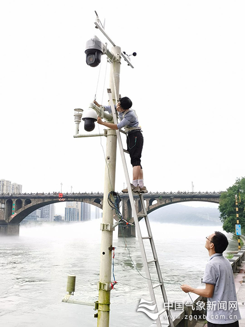
The picture shows the staff of jiande city Meteorological Bureau inspecting and strengthening the automatic meteorological monitoring facilities along Xin ‘anjiang River. Figure/Wen Wu Meng
(Source: China Meteorological News, July 8, 2020 Editor: Zhang Lin)